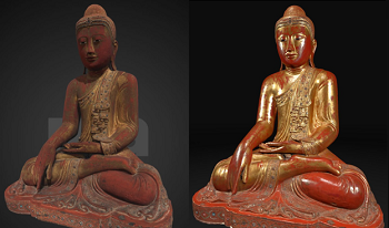
Advancements in accurate digitization of 3D objects through photogrammetry are ongoing in the cultural heritage space, for the purposes of digital archival and worldwide access. This paper outlines and documents several user-driven enhancements to the photogrammetry pipeline to improve the fidelity of digitizations. In particular, we introduce a new platform for capturing empirically-based specularity of 3D models called Kintsugi 3D, and visually compare traditional photogrammetry results with this new technique. Kintsugi 3D is a free and open-source package that features, among other things, the ability to generate a set of textures for a 3D model, including normal and specularity maps, based empirically on ground-truth observations from a flash-on-camera image set. It is hoped that the ongoing development of Kintsugi 3D will improve public access for institutions with an interest in sharing high-fidelity photogrammetry.

The United States of America has an estimate of 84,000 dams of which approximately 15,500 are rated as high-risk as of 2016. Recurrent geological and structural health changes require dam assets to be subject to continuous structural monitoring, assessment and restoration. The objective of the developed system is targeted at evaluating the feasibility for standardization in remote, digital inspections of the outflow works of such assets to replace human visual inspections. This work proposes both a mobile inspection platform and an image processing pipeline to reconstruct 3D models of the outflow tunnel and gates of dams for structural defect identification. We begin by presenting the imaging system with consideration to lighting conditions and acquisition strategies. We then propose and formulate global optimization constraints that optimize system poses and geometric estimates of the environment. Following that, we present a RANSAC frame-work that fits geometric cylinder primitives for texture projection and geometric deviation, as well as an interactive annotation frame-work for 3D anomaly marking. Results of the system and processing are demonstrated at the Blue Mountain Dam, Arkansas and the F.E. Walter Dam, Pennsylvania.

Coral reef ecosystems are some of the diverse and valuable ecosystems on earth. They support more species per unit area than any other marine environment and are essential to the sustenance of life in our oceans. However, due to climate change, only under 46% of the worlds coral were considered healthy as of 2008. One of the biggest challenges with regard to coral conservation is that reef mapping is currently carried out manually, with a group a divers manually moving and placing a large PVC quadrat for every unit area of the reef and then photographing and analyzing each unit separately. Hence, there is a pressing need to improve the methodology of imaging, stitching and analyzing coral reef maps in order to make it feasible to protect them and sustain life in our oceans. To improve the current methodology, a reef-mapping surface drone robot which photographs, stitches and analyzes the reef autonomously was built. This robot updates the physical quadrat which is used today, to a projected laser quadrat, which eliminates the need to dive to the bottom of the sea and allows relative pose estimation. The robot then captures and processes the images and using 3D reconstruction and computer vision algorithms is able to map and classify the coral autonomously.