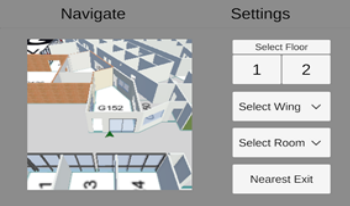
During emergencies, accurate and timely dissemination of evacuation information plays a critical role in saving lives and minimizing damage. As technology continues to advance, there is an increasing need to explore innovative approaches that enhance emergency evacuation and navigation in an indoor environment to facilitate efficient decision-making. This paper presents a mobile augmented reality application (MARA) for indoor emergency evacuation and navigation in a building environment in real time. The location of the user is determined by the device camera and translated to a position within a Digital Twin of the Building. AI-generated navigation meshes and augmented reality foundation image tracking technology are used for localization. Through the visualization of integrated geographic information systems and real-time data analysis, the proposed MARA provides the current location of the person, the number of exits, and user-specific personalized evacuation routes. The MARA can also be used for acquiring spatial analysis, situational awareness, and visual communication. In emergencies such as fire and smoke visibility becomes poor inside the building. The proposed MARA provides information to support effective decision-making for both building occupants and emergency responders during emergencies.

Routing through a dynamic environment is mostly carried out by using maps that integrate information about time-dependent parameters, such as traffic conditions and spatial constraints, which is a challenging and cumbersome task. We address the complex scenario where a user has to plan a route on a network that is dynamic with respect to edges that change their congestion through time. We perform an experimental user study where we compare interactive and non-interactive interfaces, the complexity levels of the map structures (number of nodes and edges) and of the paths (number of nodes that need to be visited), and the effects of familiarity with the map. The results of our study indicate that an interactive interface is more beneficial than a non-interactive interface for more complex paths, while a non-interactive interface is more beneficial than an interactive interface for less complex paths. In detail, while the number of nodes and edges of the network had no effect on the performance, we observed that (not surprisingly) the more complex the path, the longer the processing time and the lower the correctness. We tested the familiarity with a test–retest design, where we organized a second session of tests, labeled T2, after the first session T1. We observed a familiarization effect in T2, that is, the participants’ performance improved for the networks known from T1.

Successful navigation requires spatial cognition abilities, primarily the development of an accurate and flexible mental, or cognitive, map of the navigational space and of the route trajectory required to travel to the target location. To train the spatial cognition abilities and spatial memory underlying successful navigation, we translated the power of the Likova Cognitive-Kinesthetic Rehabilitation Training, initially developed for the manual domain of operation, to the domain of navigation. In the tasks requiring the mentally-performed navigational decision planning (planning the shortest or the reversed shortest path between newly-specified locations on a just memorized tactile map) and memory-guided motor execution of these decisions (accurate drawing the respective planned paths), the most significant brain activation increase was found in the two medial posterior cortical regions (DLPFC, insula), in contrast to a very little change in the lateral anterior regions (occipital V1-V4, the retrosplenial/precuneus) for most of these tasks. By extending our previous findings from the manual to the navigation domain, these results demonstrate the power of a multidisciplinary approach incorporating art, behavioral and neuroscience methodologies to drive much-needed plasticity in the adult brain.

This paper proposes a method with which mobile robots can explore unknown environments efficiently and effectively. For mobile robots, developing exploration methods in unknown environments is a challenging target. Navigation for environment monitoring is necessary in order to explore efficiently in unknown environment. Although a frontier-based exploration can be seen as a conventional method, this method is not necessarily a global optimal planning method, because it explores for the local optimal in each situation; in the monitoring task, it could fall into the local solution, because it could not take into consideration the overall observation efficiency. The proposed method exploits the whole observation and knowledge about the area of the unknown environment. It is possible for the proposed method to establish a global plan in consideration of efficiency and effectiveness by integrating pattern and frontier-based exploration. In simulation, it is shown that the proposed method of pattern and frontier-based exploration is useful for exploring unknown environments efficiently and effectively.