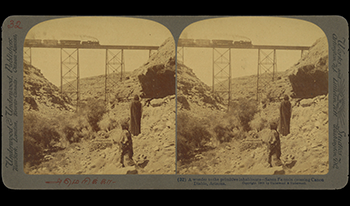
Vast archives of stereographic photographs from the 19th and 20th centuries survive in collections worldwide. While extensively digitized, these artifacts remain largely inaccessible in their intended three-dimensional form. Contemporary stereoscopic displays offer ideal platforms for experiencing these historical media, yet a significant barrier persists: the labor-intensive process of restoring deteriorated stereographs for comfortable viewing. This paper addresses this challenge through two approaches: first, establishing a comprehensive framework for manual stereograph restoration that balances historical authenticity with viewing comfort; second, presenting our ongoing development of an automated pipeline that leverages recent advances in computer vision. Our approach aims to dramatically reduce the time and expertise required for restoration, potentially enabling unprecedented access to historical stereographic archives and facilitating their reintroduction to contemporary audiences through immersive technologies.

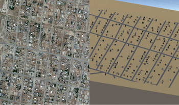
Traffic simulation is a critical tool used by psychologists and engineers to study road behavior and improve safety standards. However, the creation of large 3D virtual environments requires specific technical expertise that traditionally trained traffic researchers may not have. This research proposes an approach to utilize fundamental image processing techniques to identify key features of an environment from a top-down view such as satellite imagery and map. The segmented data from the processed image is then utilized to create an approximate 3D virtual environment. A mesh of the detected roads is automatically generated while buildings and vegetation are selected from a library based on detected attributes. This research would enable traffic researchers with little to no 3D modeling experience to create large complex environments to study a variety of traffic scenarios.

Deep learning has enabled rapid advancements in the field of image processing. Learning based approaches have achieved stunning success over their traditional signal processing-based counterparts for a variety of applications such as object detection, semantic segmentation etc. This has resulted in the parallel development of hardware architectures capable of optimizing the inferencing of deep learning algorithms in real time. Embedded devices tend to have hard constraints on internal memory space and must rely on larger (but relatively very slow) DDR memory to store vast data generated while processing the deep learning algorithms. Thus, associated systems have to be evolved to make use of the optimized hardware balancing compute times with data operations. We propose such a generalized framework that can, given a set of compute elements and memory arrangement, devise an efficient method for processing of multidimensional data to optimize inference time of deep learning algorithms for vision applications.

Personal real-time video monitoring devices are popular in recent years especially for people living in bigger houses who are taking care of babies. People take advantage of a real-time video monitoring device to monitor the babies’ activities while they are occupied by other issues. However, danger happens any time in any situations. It is necessary for a baby monitoring device to have a motion detection function to trigger recording functions or alert the guardians. This paper introduces a solution for the motion detection problem. The solution combines statistical methods, kernel density estimation and histogram analysis methods, and deep learning method for detecting the salient object. The final outputs are both the motion levels indicating the severity of the motions and the bounding boxes indicating the location of the motion happening in the video frame. The different levels of motion can later be used as triggers for different functions built into the device, such as starting video recording, playing sirens, etc., and the bounding boxes can provide reference focus areas for the guardians to check the details of the motion to decide whether to take actions or not.

Nitrate sensors are commonly used to reflect the nitrate levels of soil conditions in agriculture. In a roll-to-roll system, for manufacturing Thin-Film nitrate sensors, varying characteristics of the ion-selective membrane on screen-printed electrodes are inevitable and affect sensor performance. It is essential to monitor the sensor performance in real-time to guarantee the quality of the products. We applied image processing techniques and offline learning to realize the performance assessment. However, a large variation of the sensor’s data with dynamic manufacturing factors will defeat the accuracy of the prediction system. In this work, our key contribution is to propose a system for predicting the sensor performance in on-line scenarios and making the neural networks efficiently adapt to the new data. We leverage residual learning and Hedge Back-Propagation to the on-line settings and make the predicting network more adaptive for input data coming sequentially. Our results show that our method achieves a highly accurate prediction performance with compact time consumption.

A novel acceleration strategy is presented for computer vision and machine learning field from both algorithmic and hardware implementation perspective. With our approach, complex mathematical functions such as multiplication can be greatly simplified. As a result, an accelerated machine learning method requires no more than ADD operations, which tremendously reduces processing time, hardware complexity and power consumption. The applicability is illustrated by going through a machine learning example of HOG+SVM, where the accelerated version achieves comparable accuracy based on real datasets of human figure and digits.


Automobile manufacturers identify paint used on their vehicles with identification codes. However, as many automobile manufacturers use different and proprietary naming conventions to these codes, it can be challenging for a normal person to find the specific type of paint applied to a vehicle. In this paper, we facilitate this process by developing a portable mobile system to detect paint codes for vehicles. To determine the best matching paint code using the images captured by a mobile device, several practical issues should be examined. First of all, multiple images are captured through the camera viewfinder and the same collection of pixel values are computed collectively to estimate the most accurate color across a short period of time. Second, all pixels in a square region centered on the selected spot are sampled for color estimation to achieve the best match. Finally, in case multiple matches are detected, the closest match should be displayed to the user first, followed by the next closest values. Extensive experiments demonstrate the color detection and matching functionality of our system is robust against varying lighting environments. The scope of this work can be further expanded to other painting industries such as furniture making and construction.

Coral reef ecosystems are some of the diverse and valuable ecosystems on earth. They support more species per unit area than any other marine environment and are essential to the sustenance of life in our oceans. However, due to climate change, only under 46% of the worlds coral were considered healthy as of 2008. One of the biggest challenges with regard to coral conservation is that reef mapping is currently carried out manually, with a group a divers manually moving and placing a large PVC quadrat for every unit area of the reef and then photographing and analyzing each unit separately. Hence, there is a pressing need to improve the methodology of imaging, stitching and analyzing coral reef maps in order to make it feasible to protect them and sustain life in our oceans. To improve the current methodology, a reef-mapping surface drone robot which photographs, stitches and analyzes the reef autonomously was built. This robot updates the physical quadrat which is used today, to a projected laser quadrat, which eliminates the need to dive to the bottom of the sea and allows relative pose estimation. The robot then captures and processes the images and using 3D reconstruction and computer vision algorithms is able to map and classify the coral autonomously.